
The project draws on data produced by JUNEAU and JANUSS, including field observations, monitoring data, satellite imagery, modelling outputs and algorithm-based analyses. DATA collects, structures and documents these resources, making them easier to share, explore and reuse in subsequent stages of the programme, particularly within the PREDICTION and DIGITAL TWINS projects.
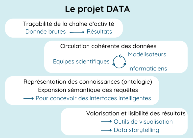
Schéma du projet DATA
Anouk Fronzes, BRGM
DATA also develops data catalogues and application programming interfaces (APIs), providing access to datasets and processing services. These tools help users find and work with a wide range of environmental information, from hydrological and climate data to geological datasets.
Another key aspect of the project is the development of scientific data processing workflows. Automated orchestration tools coordinate the different stages of data processing, from acquisition to analysis. Each step is recorded and documented, ensuring that results can be traced, verified and reproduced.
Data Organisation and Interoperability
Environmental data come from many different sources, including scientific instruments, numerical models and research infrastructures. As a result, they often vary significantly in format and structure. DATA addresses this challenge by harmonising datasets so they can be compared, combined and analysed together.
This work focuses on three key principles:
- Metadata: systematically documenting datasets, including their origin, collection methods, time periods, measurement units and processing levels.
- Data harmonisation and standardisation: bringing together information from different sources using consistent formats and structures to support meaningful comparisons and joint analyses.
- Interoperability: enabling different software applications, models and platforms to access and use the same datasets, making it easier to exchange information and integrate data into processing workflows.
The project also explores automated data profiling techniques to extract meaningful information from poorly structured or unstructured sources. An important part of this work is distinguishing raw data, collected by instruments or generated through simulations, from data that have been processed and prepared for scientific analysis. Documented processing workflows ensure that this transformation remains transparent and reproducible.
Once structured, datasets can be organised into data cubes, which bring together several dimensions, such as location, time and environmental variables. This approach makes it easier to explore large spatiotemporal datasets and understand how environmental conditions change over time.
Together, these activities form the foundation of DATA's scientific data engineering approach, with a strong emphasis on data quality, traceability and reproducibility.
Knowledge Representation
DATA also investigates new ways of organising and representing scientific knowledge to make environmental information easier to find and use.
One approach involves ontologies: structured representations of concepts and the relationships between them within a particular field of research. For example, an ontology can describe how environmental variables, natural systems and physical processes relate to one another.
These knowledge models can improve:
- Information retrieval, by making it easier to locate relevant data across different databases;
- Query interpretation, by recognising synonyms, related concepts and connections between scientific terms;
- Data exploration, by helping users navigate and analyse complex datasets.
In the longer term, this research aims to support the development of intelligent interfaces that guide users through the process of exploring environmental data. Such tools could help formulate queries, identify relevant datasets and navigate large volumes of information, even for users without specialist knowledge.
Ultimately, the aim is to make interactions between users, environmental data and JUNON's modelling tools more intuitive and effective.
Making Data Accessible
Beyond organising and managing data, DATA develops tools to help users explore, interpret and make practical use of environmental information.
These include:
- Spatiotemporal data exploration and analysis tools, allowing users to search, examine and analyse environmental datasets;
- Data visualisation and communication tools, including dashboards and data storytelling approaches that make complex results easier to understand;
- User-friendly interfaces providing access to data and analyses for different audiences, from scientific researchers to environmental management professionals.
These tools help users track environmental changes and keep analyses up to date as new observations become available.
They also provide an essential link to JUNON's digital twins, making it easier to access the underlying data, explore model outputs and interpret simulation results.
Scientific lead:

Chef de projet Grande Infrastructure de Recherche
BRGM, 3 avenue Claude Guillemin, BP36009
45100 Orléans
France