
• JUNEAU-Quant, dedicated to assessing and forecasting groundwater availability;
• JUNEAU-Qual, focused on monitoring and predicting changes in groundwater quality, particularly in relation to contamination.
These two digital twins complement JANUS, dedicated to air quality, and JUNHI, focused on wetlands and their interactions with the atmosphere. Together, they form the four environmental digital twins developed under the JUNON programme.
JUNEAU contributes to the databases structured within the DATA project, the datasets and models used in the PREDICTIONS project, as well as the technical specifications and scientific expertise required for the DIGITAL TWINS project.
It relies on a multi-scale approach combining groundwater level measurements, hydrogeochemistry, numerical modelling and artificial intelligence, with a commitment to open science and the development of accessible digital services.
A living laboratory: the unconfined Beauce aquifer
The Beauce aquifer is a strategic groundwater resource for the Centre-Val de Loire region. However, it faces significant pressures from agriculture, climate change and urban development.
The project draws on:
- existing databases (ADES, BSS);
- experimental platforms developed under the PIVOTS programme (O-ZNS, DECAP);
- an enhanced monitoring network combining historical data, field campaigns and continuous sensor measurements.
Improving our understanding of groundwater resources
JUNEAU focuses on three main objectives:
- Collect the data required to assess groundwater resources quantitatively.
- Improve knowledge of regional hydrogeological processes, as well as the presence, transport and behaviour of human-derived contaminants, particularly nitrates and pesticides.
- Optimise groundwater quantity and quality monitoring to support their integration into the JUNEAU-Quant and JUNEAU-Qual predictive digital twins.
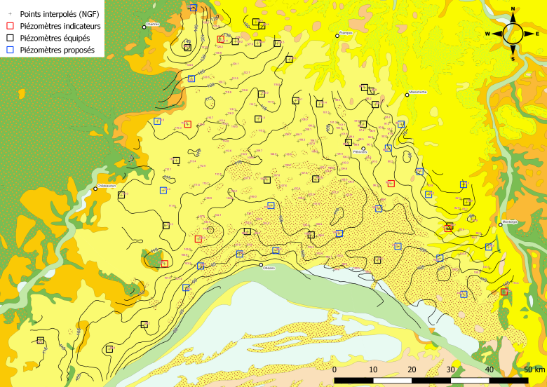
L’élaboration du jumeau Quantité : recensement des piézomètres pouvant nourrir les modèles en données
© BRGM
Real-time monitoring: towards a dynamic groundwater map
In 2023, fieldwork carried out within the JUNEAU project led to:
- the completion of groundwater level measurement campaigns in the Pithiviers and Étampes aquifers, during low-water (January) and high-water (May) periods;
- improvements to the groundwater level map of the unconfined Beauce aquifer, a key component of JUNEAU-Quant, enabling dynamic updates based on strategically located monitoring points;
- the installation of sensors continuously measuring groundwater levels and selected water quality parameters, particularly nitrate concentrations, at several pilot sites.
These data now feed into a groundwater level map updated in near real time, making it possible to visualise aquifer conditions and improve model calibration.
Understanding aquifer behaviour through hydrogeological zoning
A comprehensive analysis of water quality data available in ADES, groundwater level time series and information from the BSS database has enabled the identification of areas with similar hydrogeological behaviour. This zoning process is essential for the development of the digital twins.
Most of the study area exhibits relatively homogeneous behaviour associated with the outcropping Pithiviers geological formation.
However, several sectors display specific hydrogeological characteristics. These include the southern sector, influenced by the Loire River; the eastern sector, in contact with the Fontainebleau, Brie and Eocene sands and sandstones; and the southeastern sector, located beneath the Sologne sands and clays in the Orléans Forest.
JUNEAU-Quant: simulating changes in groundwater resources
JUNEAU-Quant aims to anticipate changes in groundwater levels through innovative approaches combining conventional numerical hydrogeological models, neural network models (artificial intelligence) and hybrid modelling techniques.
It will help assess the local impacts of climate change, anticipate drought and groundwater flooding risks, and estimate future groundwater availability.
The objective? To provide practical decision-support tools for water managers and regional stakeholders.
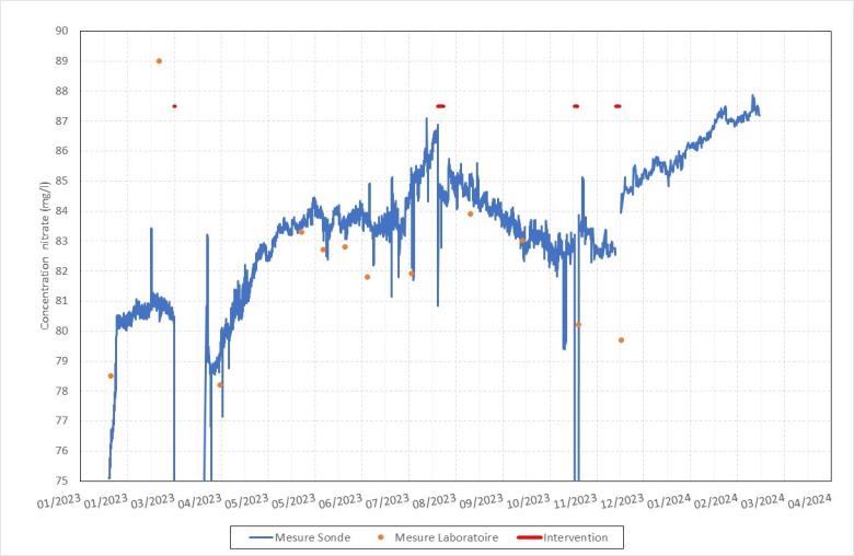
Exemples de mesures pour la concentration en nitrates
© BRGM
JUNEAU-Qual: monitoring groundwater quality
Groundwater quality, particularly in relation to nitrates from agricultural activities, represents a major environmental challenge.
The work carried out has made it possible to analyse spatial and temporal variations in nitrate concentrations, identify different patterns of behaviour and highlight more vulnerable areas requiring enhanced monitoring.
Specific developments have included:
- refining the specifications for an in situ pesticide monitoring sensor;
- designing an experimental protocol to test nitrate sensors;
- installing continuous nitrate monitoring sensors at three pilot sites in Beauce, including the O-ZNS site in Villamblain.
These advances lay the foundations for the JUNEAU-Qual digital twin, which will make it possible, for example, to model and simulate pollutant transport and support more sustainable agricultural practices.
A collaborative project
BRGM coordinates the scientific activities and provides its expertise in hydrogeology. Modelling activities and monitoring of the experimental site are carried out by ISTO (CNRS). ICMN contributes to sensor characterisation and reliability through the DECAP platform.
Several regional partners are also involved in the project, including SDEC, which supplies monitoring sensors, and GABOR 45, which helps establish links with agricultural practices.
Towards digital services for local communities
Through JUNEAU-Quant and JUNEAU-Qual, the JUNON programme aims to develop practical digital services for local stakeholders: interactive groundwater maps, seasonal groundwater level forecasts, localised water quality indicators, and decision-support tools for sustainable and proactive groundwater management.
These services are being progressively deployed as part of the JUNON programme.
Project leads:

BRGM, 3 avenue Claude Guillemin, BP36009
45100 Orléans
France

BRGM, 3 avenue Claude Guillemin
45100 Orléans
France